Oklahoma City, OK – A blast of Arctic air and winter precipitation is on the way to western Oklahoma, bringing the first real chance of measurable snow and icy conditions of the season for Elk City, Weatherford, Clinton and surrounding areas.
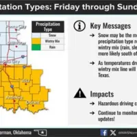
According to the National Weather Service in Norman, much of Oklahoma could see accumulating snow from Friday through Sunday. Snow chances are highest roughly north of Interstate 40, though a wintry mix of rain, sleet and freezing rain could push south as temperatures drop Friday into Saturday. A light glaze of ice remains possible across portions of central and southern Oklahoma as well.
Snow probabilities show a solid chance for at least an inch of snow in western Oklahoma over the weekend. More than a trace is likely, with the best chance for measurable snow across northwest and central portions of the forecast area. A thin layer of ice could make bridges and untreated roads slick, especially early Saturday morning.
Behind the precipitation, a strong cold front will plunge temperatures well below freezing. Highs on Saturday and Sunday are expected to stay below freezing, with wind chills making it feel even colder. Some spots may go more than 48 hours without climbing above 32 degrees.
Travel impacts
Road conditions could deteriorate quickly Friday night into Sunday morning, especially on rural roads and overpasses. Drivers are urged to plan extra travel time, stay updated on forecast changes and be prepared for slick spots due to ice.
Timing at a glance
-
Friday: Arctic front moves in. Cold air overspreads the region late afternoon.
-
Friday night: Snow and wintry mix arrive in the west.
-
Saturday: Snowfall likely, especially north of I-40. Icy patches possible south of I-40.
-
Sunday: Cold continues, lingering snow/flurries taper off.
Forecasters say this system has the potential to bring the coldest air of the season so far, and residents should monitor updates through the weekend as snow amounts and ice potential could shift.
Copyright 2025 Paragon Communications. All rights reserved. This material may not be published, broadcast, rewritten, or redistributed without permission.


