Arnett, OK – On Sunday evening an EF-2 tornado touched down southwest of Arnett in Ellis County. The storm damaged homes, outbuildings, oil field sites, and an Arnett school building. Power lines and trees were downed, and one county road was closed. Fortunately, no injuries or fatalities have been reported.
The tornado was part of a supercell that produced four tornadoes—three near Arnett and one in Texas.
Severe Weather Forecast for Tonight
The National Weather Service has issued a moderate (Level 4 of 5) severe weather risk for central and eastern Oklahoma, including Ellis County. The primary threats include strong to violent tornadoes, very large hail (up to 3 inches), damaging winds, and flash flooding.
Residents are advised to stay weather-aware and monitor local alerts through the evening.
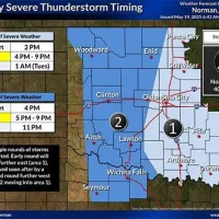
Severe Storms Expected Across Western Oklahoma This Evening
Strong to severe thunderstorms are expected to develop across western Oklahoma this afternoon, with the first storms likely forming as early as 4 PM. These storms will move east-northeast at 40–50 mph, impacting areas like Elk City, and Clinton before pushing into central Oklahoma later in the evening.
According to the National Weather Service in Norman, multiple rounds of storms are possible. The most likely window for severe weather in western counties is between 5 PM and 9 PM, with threats winding down by around 11 PM.
Key Threats:
Tornadoes: Medium risk in Custer, Beckham, and Washita; low risk in Roger Mills. A few strong tornadoes (EF-2+) are possible.
Hail: Up to softball size in the most intense cells.
Wind: Gusts of 80+ mph could accompany some storms.
The first round of storms may start in western Oklahoma, followed closely by additional development further east. This staggered timing means some locations could experience multiple waves of dangerous weather.
Keep your NOAA weather radio on, stay tuned to KECO 96.5FM, and follow local alerts for real-time updates and safety info.
For official updates, visit: weather.gov/norman


