Roger Mills County, OK – A coordinated, countywide emergency response helped stop four grass fires Friday afternoon, Jan. 16, with minimal damage despite ongoing drought conditions and elevated fire danger.
According to information provided by Roger Mills County Emergency Management, Friday had been declared a “war day,” prompting heightened fire readiness across the county. Preparations began Thursday with road graders pre-positioned throughout Roger Mills County, water tankers staged at all three district yards, and all eight county fire departments placed on all-call status. Volunteer departments were staffed or had personnel on standby to respond quickly.
The advance planning paid off Friday afternoon.
At 3:18 p.m., the National Weather Service issued a satellite-based hot spot detection north of Durham. Crawford Fire Department was dispatched immediately and was already en route before the first public report of smoke came in at 3:30 p.m. At that time, all departments were paged to their stations. Crawford and Reydon units responded along with a county road grader that was parked less than a mile away. The fire was quickly brought under control.
While crews were refilling water tanks, a second grass fire with a structure threatened was reported within five miles of the first fire. Within five minutes, six to seven fire units and a grader were on scene, with a second grader en route. That fire was also contained quickly, preventing damage to nearby property.
At 5:24 p.m., departments were dispatched to a third fire one mile south of Roll. Crawford and Reydon responded from the Durham area, joined by Strong City, Cheyenne, Berlin, Sweetwater, and Leedey fire departments. Hammon remained on standby to protect the east side of the county. Two graders assisted fire crews, and forward progress of the fire was stopped shortly after arrival.
Less than 30 minutes later, at 5:49 p.m., departments were dispatched to a fourth fire approximately 3.5 miles east of Durham. Leedey, Sweetwater, Berlin, Crawford, and Reydon units, along with a grader, were diverted from the Roll area while Strong City and Cheyenne continued mop-up operations. That fire was also quickly brought under control.
By 7:45 p.m., all four fires were fully extinguished and units were able to return home. No structures were lost, and total grass loss across all fires was estimated at 100 acres or less. Although the fires were considered suspicious in nature, the early detection, fast response, and coordinated effort prevented a more serious situation.
Officials credited the outcome to strong preplanning, the dedication of volunteer firefighters and county employees, and assistance from the Roger Mills County Sheriff’s Office, Oklahoma Highway Patrol, and county dispatch. Dispatchers were credited for providing clear, calm, and concise directions during a very busy and stressful day.
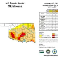
The fires occurred as drought conditions continue to expand across much of Oklahoma. The latest U.S. Drought Monitor shows the Panhandle and far northwest Oklahoma remain largely free of dry conditions. However, southwestern and southern Oklahoma have seen increases in drought intensity.
Extreme drought increased from 6.92 percent of the state the previous week to 7.44 percent. Areas classified as abnormally dry also grew, rising from 80.85 percent to 82.14 percent statewide, while moderate drought coverage declined slightly.
Looking ahead, western Oklahoma is expected to see cold and potentially hazardous weather through the weekend. Friday is forecast to bring daytime highs in the mid to upper 30s, with rain possibly changing to freezing rain or snow, especially in northwest areas. Winds will increase, and icy conditions may develop. Overnight lows are expected to fall into the low teens.
Saturday will remain very cold, with highs in the low 20s and lows again near the teens. Mostly cloudy skies and periods of snow are possible, and wind chills will make conditions feel even colder.
Officials urge residents to use caution, avoid outdoor burning, and remain alert to changing weather and fire conditions. Travel could become slick in spots if winter precipitation accumulates.
Copyright 2025 Paragon Communications. All rights reserved. This material may not be published, broadcast, rewritten, or redistributed without permission.


